|  The
temptation to reproduce countless maps of North Aston
and its surroundings down the ages was resisted by the
book's editors, since many are already readily accessible
through other sources, but a number of significant examples
have been found and are featured in the book. These
include up-to-date maps showing local footpaths, for
example, and another of the North Aston golf course
- now overgrown, but in the 1990s one of the longest
privately-owned courses in Britain. The
temptation to reproduce countless maps of North Aston
and its surroundings down the ages was resisted by the
book's editors, since many are already readily accessible
through other sources, but a number of significant examples
have been found and are featured in the book. These
include up-to-date maps showing local footpaths, for
example, and another of the North Aston golf course
- now overgrown, but in the 1990s one of the longest
privately-owned courses in Britain.
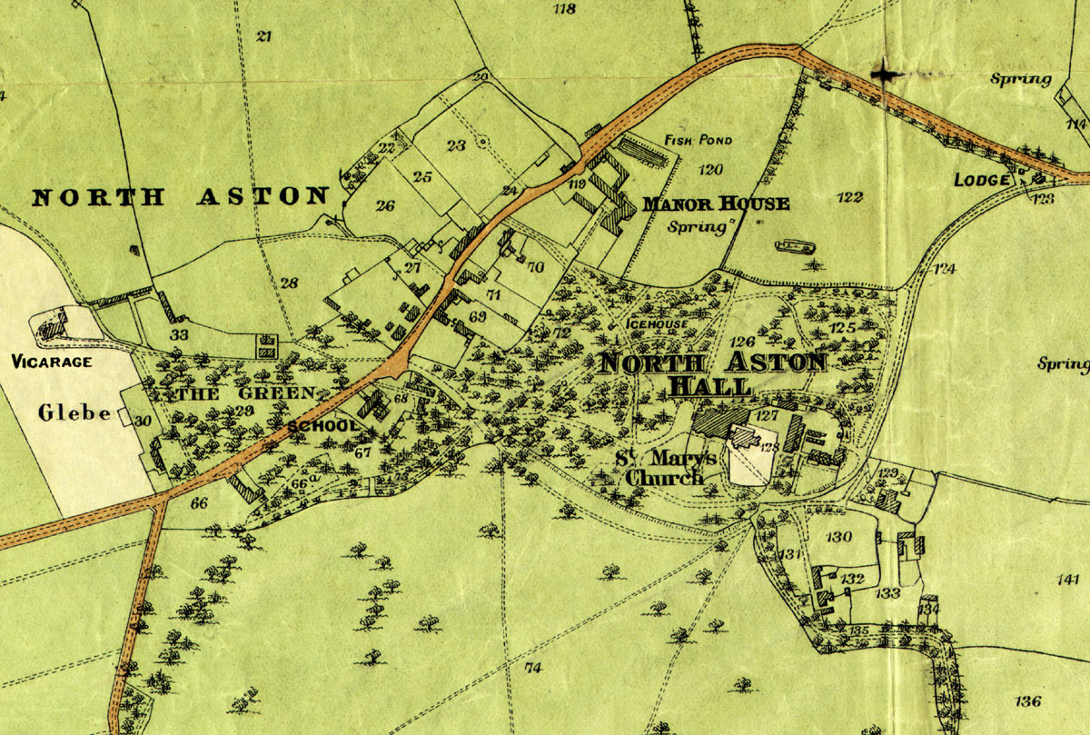
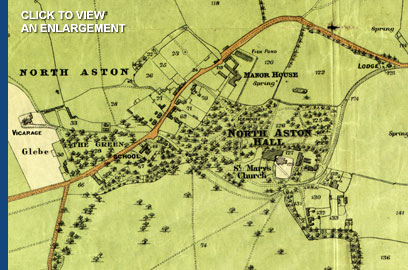
By
far the most significant map is the one that accompanied
the sales brochure for 1907, an extract from which is
illustrated on the right.
This
was the last occasion that the entire village of North
Aston was sold as a single entity, and since that time
many aspects of the Estate have changed, with individual
buildings and homes sold off, other lands acquired,
and a number of private houses constructed. However,
the agent's map that helped to promote that sale a century
ago remains as one of the most valuable references for
the community, and has been adapted within North
Aston - A Millennium to help record many of the
historical features of the village, including the ancient
field names.
 The
names given to the fields have, in some cases, been
handed down over the generations, and their origins
long lost with the passing years. Families from North
Aston’s past crop up from time to time - Mobbs,
Beesley, Wing, Watson - while other names are clearly
derived from topographical features. The
names given to the fields have, in some cases, been
handed down over the generations, and their origins
long lost with the passing years. Families from North
Aston’s past crop up from time to time - Mobbs,
Beesley, Wing, Watson - while other names are clearly
derived from topographical features.
Perhaps
the field with the most curious, or controversial title,
is Bustards Hill (17) on Manor Farm. It has been written
in various other forms, such as: Bustin's Hill, Bussons
Hill and Bust'ems Hill. The one held to be correct by
the Knight family was “Bust'ems”, because
it was where the plough horses were 'broken to the plough',
the ground being very clayey there.
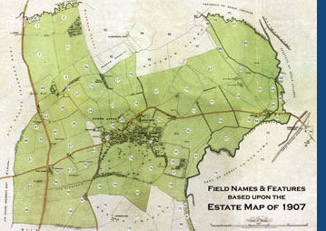
All
the various houses, building, gardens, fields and features
of the Estate were marked and numbered on the 1907 map,
and the numbers corresponded to listings in the sales
brochure itself. The editors have used that same numbering
system to record the field names:
|
1
First Meadow (aka Small Covert Dairy Ground or
First Road Meadow)
2 Far Meadow (aka Big Covert Dairy Ground or Second
Road Meadow)
3 Dane Hill Covert
4 Dane Hill Spinney
5 Unallocated
6 Rick Yard
7 (First) Dairy Ground
8 Polo Field (part of Great Ploughed Ground with
8a)
8a Hilly Ground Field (part of
Great Ploughed Ground with 8)
9 Unallocated
10 Ram Spinney Ground (or Field, part of Banbury
Ground with 21)
11 Covert Dairy Ground (aka Far Dairy Ground)
12-15 Unallocated
16 Ram Spinney
17 Bust'ems Hill (aka Bustards, Bustin's, Bussons
or Bustham's Hill)
18 The Slade
19 Yard and Buildings
20 Vegetable Garden
21 Banbury's Ground (split into Banbury's Ground
East and Banbury's Ground West)
22 Orchard
23 Kitchen Garden (now site of Jericho House)
24 Old English Flower Garden
25 Vegetable Garden
26 Wilkins Close (Paddock, Stable , etc)
27 Stone Built Cottage with Bakehouse and Garden,
Shop, Cottage and Garden, Pair of Stone Built
Cottages and Gardens, Two Pair of Stone-Built
and Slated Cottages and Gardens (now sites for
5, 6, 7, 8 and 9 Somerton Road)
28 Beesley's Close
29 The Village Green
30 Two Cottages and Gardens (now 21 and 22 The
Green)
31-32 Unallocated numbers
33 Pair of Stone Built and Slated Cottages and
Gardens, Three Cottages and Gardens, Two Cottages
and Gardens. (Now sites for 14-20 The Green inclusive)
34 Mill Ground (aka Mill Field/Close, part of
Busswell’s Ground with 37)
35 Ram Field/Close (aka Dean’s Second Ground,
part of Dean’s Ground with 36, 43 &
45)
36 Step Hill Ground (aka Dean’s Plouged
Ground, part of Dean’s Ground with 35, 43,
& 45)
37 Stepstile Ground (aka Step Hill Ground, part
of Busswell’s Ground with 34)
38 Pole Spinney Side lands
39 Dane Hill Farm, Yard, Buildings, etc, with
(a) Rick Yard
40 House Ground
41 Garden
42 Cottage, Stable Buildings and garden (Sykes
Family) Two Cottages and Gardens (now sites for
Dawn Cottage, Bray Cottage, Step Hill Cottage)
43 Ram Field/Close (aka Dean’s Third Ground,
part of Dean’s Ground with 35, 36 &
45)
44 Yard and Buildings
45 Ram Field/Close (aka Dean’s First Ground,
part of Dean’s Ground with 35, 36 &
43)
46 Unallocated number
47 Lime Kiln Field
48 Lime Kilns, Quarry and Grass
49 Lower Rush Beds
50 (Roger’s) Rush Beds
51 Upper Rush Beds
52 Unallocated
53 Home Field or Home Ground (aka First Upper
Field)
54 Dobson's Field (aka Home Ground)
55 House, Yard, Buildings etc (now site of The
Fox and Park Farm House)
56 Fox Inn Close
57 Watson's Ground (aka Hatton's Ground)
58 Buildings and Yard
59 Buildings and Yard (now Park Farm Barns)
60 Unallocated number
61 Middle Ground (aka Stonepick Ground or Quarry
Field)
62 Unallocated
63 The Allotments
64 Unallocated
65 Barn Ground (aka Allotment Field)
66 Ornamental Woodland. Three Cottages, Gardens
and Buildings, plus Cottage and Garden. (Now sites
for Magnolia Cottage, 2 and 3 Greenside Cottages
and Windana)
67 Ornamental Woodland. Also known as The Spinney.
(Now site for 1, 2, 3, and 4 The Green, Danesmoor,
Sparrows and The Green)
68 School, and Four Cottages, Gardens and Lodge
(now sites for School Cottages, Gate Cottage,
Middle Cottage and Nether Cottage)
69 Four Cottages and Gardens, Post Office (now
sites for 12, 13 Somerton Road, Old Post Office
and Merrystones)
70 Stone Built and Thatched House and Garden (now
site of Rosemary Cottage)
71 Timber Yard, Buildings and Saw Pit. Two Cottages
and Gardens (now sites for 10 and 11 Somerton
Road)
72 Ornamental Woodland
73 Ornamental Woodland
74 The Park (split into Top Park (a)
and Bottom Park (b)
75 Woodland
76-85 Unallocated numbers
86 Rice Ham Meadow |

|
87
The Common
88 Unallocated
89 Bestmoor
90 The Side Land
91 Old Gravel Pit
92 Willow Bed
93 The Barn Ground (with 94 and 96)
94 Upper Close (part of The Barn Ground with 93
and 96)
95 Rick Yard and Buildings (now site of Mill Cottage)
96 Home Close (part of The Barn Ground with 93
and 94)
97 The Mill Stream (upstream of The Mill)
98 The Long Ham
99-102 Unallocated numbers
103 The Ham or Mill Tail Close
104 Mill Close, beside The River Cherwell
105 Mills, Residence, Buildings, etc. (North Aston
Mill)
106 Mill Ground or Field
107 Cross Meadow (aka Large Meadow. Area to east
known as Poor Lands)
108
Manor Close (aka North Close or Dairy Ground)
109 Gravel Pit (Hill)
110 Old Gravel Pit
111 Upper Middle Field
112 Yard and Buildings
113 The Pike
114 Paddock and Spring
115 Home Ground (split into The Great Ploughed
Ground, North, and The Little Ploughed Ground,
South)
116 Yard, Buildings, etc (now the site of Manor
Farm)
117 The Great Ground
118 Town Leys
119 Manor House, Yard, Buildings, etc
120 The Closes (Paddock)
121 Unallocated
122 North Close
123 Lodge and Spinney
124 Carriage Drive
125 Ornamental Woodland
126 Mansion, Gardens, Lawns, etc (now site for
The Hall)
127 Stabling, Frame Yard, Buildings, etc (now
sites for Coach House, Bradenstoke Barn and The
Stables)
128 The Church of St Mary's
129 Laundry, Garden etc (now site of Lower House)
130 Vegetable Garden
131 Cottage Gardens
132 Pair of Stone Built and Thatched Cottages
and Gardens (now site of Kings Wednesday)
133 Orchard and Paddock
134 Yard and Buildings
135 Park and Spinney
136 Top Folly Close (part of Folly Field, aka
Little Broad Close)
137 Folly Field
138 Woodland (The Folly)
139 Withy Bed
140 Woodland (below Folly Field)
141 Folly or Pickett Close (part of Folly Field)
142 The Lodge Ground (aka Godwin's Field or Lower
Middle Field)
143 Squire's Meadow (area to south sometimes called
Horse Moor)
144 Upper Field or Lower Upper Field (aka Second
Upper Field)
145 Reservoir Field (with 146, split into Long
Close, West, and Manuel's, East. Also sometime
known as The Great Middle Field, The Baulk and
Many Wells Field)
146 Reservoir Field (aka Little Middle Field)
147 Pole Spinney (aka Manuel's Spinney)
148 Unallocated
149 Top or Upper Wings Ground (with 154 and 155)
150-53 Unallocated numbers
154 Middle or Lower Wings Ground (with 149 and
155)
155 Bottom or Great Wings Ground (with 149 and
154)
156 Unallocated numbers
157 Woodland
158 Broads Close
159 The River Cherwell
160 Osier Bed and Stream
161 Osier Bed and Stream
Limit
of 1907 numbering system. Additional numbers added
as follows:
162
Hendon Closes (part of Hendon Charity)
163 Cold Harbour Dairy Ground (with 164-167, part
of Rousham Glebe)
164 Cold Harbour Close
(part of Rousham Glebe and Cold Harbour Dairy
Ground)
165 Mobb's Hill (with 167, part of Rousham Glebe
and Cold Harbour Dairy Ground)
166 Long Meadow
(part of Rousham Glebe and Cold Harbour Dairy
Ground)
167 Mobb's Hill (with 165, part of Rousham Glebe
and Cold Harbour Dairy Ground)
168 The Alley (aka Rough Man, Black or Rise Ham)
169 (First) Bat Willows
170 Garrett's Meadow
171 Second Bat Willows
172 Brown's Meadow
173 Grey's Close
174 Lapwing Field
175 The Sideland
176 Clay Corner
177 Hendon Close (part of Hendon Charity)
178 Hendon Dairy Ground (part of Hendon Charity)
179 Hendon Copses
180 The Seed Fields
|
|